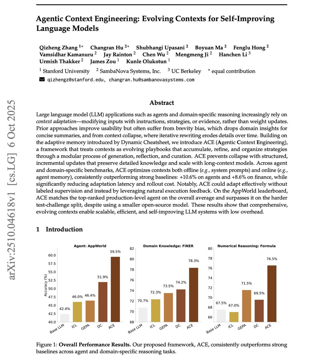
Blog

Segment Geospatial Package

The segment-geospatial package draws its inspiration from segment-anything-eo repository authored by Aliaksandr Hancharenka. To facilitate the use of the Segment Anything Model (SAM) for geospatial data, I have developed the segment-anything-py and segment-geospatial Python packages, which are now available on PyPI and conda-forge. My primary objective is to simplify the process of leveraging SAM for geospatial data analysis by enabling users to achieve this with minimal coding effort. I have adapted the source code of segment-geospatial from the segment-anything-eo repository, and credit for its original version goes to Aliaksandr Hancharenka.

Free Satelite Image Data Sources

  1. USGS Earth Explorer Web: https://earthexplorer.usgs.gov/ Data Types: Landsat optical, declassified spy (e.g. CORONA) imagery, hyperspectral (e.g. Hyperion)
  2. Sentinel / Copernicus Browser Web: https://browser.dataspace.copernicus.eu Data Types: Sentinel-2 (optical multispectral), Sentinel-1 (SAR)
  3. NASA Earthdata Search Web: https://search.earthdata.nasa.gov/ Data Types: Derived Earth science products, land cover, atmosphere, biosphere, cryosphere, etc.
  4. NOAA Data Access Viewer Web: https://coast.noaa.gov/ (Data Access Viewer) Data Types: Satellite imagery, aerial imagery, LiDAR (especially for coastal regions)
  5. Vantor Open Data Program Web: https://vantor.com/company/open-data-program/ (Open Data Program) Data Types: High-resolution optical (for disaster / emergency events), sample data including true color, stereo, building footprints, elevation
  6. Geo-Airbus Defense Web: https://space-solutions.airbus.com/imagery/sample-imagery/ (sample images) Data Types: Optical (SPOT, Pleiades), Radar (TerraSAR-X), DEM (WorldDEM)
  7. NASA Worldview Web: https://worldview.earthdata.nasa.gov/ Data Types: Scientific satellite product layers (hazards, climate, atmospheric, disaster) — can download associated data layers (GIS Geography)
  8. NOAA CLASS (Comprehensive Large Array-data Stewardship System) Web: https://www.aev.class.noaa.gov/saa/products/welcome Data Types: Oceanic imagery, atmospheric imagery (e.g. GOES, POES), environmental/climate products (aerosols, ozone, etc.)
  9. Bhuvan Indian Geo-Platform (ISRO) Web: https://bhuvan.nrsc.gov.in Data Types: Indian satellite imagery (IRS, Cartosat, ResourceSat, OceanSat), NDVI, elevation models (CartoDEM)
  10. JAXA Global ALOS 3D World Web: eorc.jaxa.jp (ALOS portal) Data Types: Global DSM / elevation (30 m) via L-band radar (ALOS)
  11. NOAA Digital Coast Web: https://coast.noaa.gov/digitalcoast/ Data Types: Coastal datasets including imagery, elevation, land cover, radar, infrared, true color composites, and socio-economic data for coastal zones
  12. PROBA-V MEP (GeoViewer) Web: viewer.probav.vito.be Data Types: PROBA-V, SPOT-Vegetation, METOP — coarse resolution vegetation / global patterns
  13. Satellite Land Cover (Global Land Cover Facility etc.) Web: (global land cover data sources via e.g. landsat, MODIS, AVHRR)m Data Types: Global land cover / land use maps (vegetation, agriculture, urban, hydrology, etc.)
  14. UNAVCO (SAR Archive / Geodesy Data) Web: https://www.unavco.org/ (SAR archive interface) Data Types: Synthetic Aperture Radar (SAR) data, geodesy / tectonic data, radar imaging for earth science applications
  15. INPE (Brazil’s National Institute for Space Research) Web: https://www.dgi.inpe.br/catalogo/ (INPE Image Catalog) Data Types: CBERS satellite imagery (optical), ResourceSat, UK-DMC, other joint mission data (especially for South America & Africa) Source: gisgeography.com and Mashford Mahute

OpenDrop Desktop Digital Biology Laboratory

OpenDrop: Desktop Digital Biology Laboratory https://www.gaudi.ch/OpenDrop/

Open source OpenDrop: https://github.com/GaudiLabs/OpenDrop

Playing Snake with OpenDrop https://www.youtube.com/watch?v=rf-efIZI_Dg

alt OpenDrop hardware

Links:

Verbalized Sampling: How to Mitigate Mode Collapse and Unlock LLM Diversity

alt stanford prompting technique

Stanford researchers built a new prompting technique!

By adding ~20 words to a prompt, it:

  • boosts LLM’s creativity by 1.6-2x
  • raises human-rated diversity by 25.7%
  • beats fine-tuned model without any retraining
  • restores 66.8% of LLM’s lost creativity after alignment

Post-training alignment methods, such as RLHF, are designed to make LLMs helpful and safe.

However, these methods unintentionally cause a significant drop in output diversity (called mode collapse).

Agents, robots, and us: Skill partnerships in the age of AI

AI is expanding the productivity frontier. Realizing its benefits requires new skills and rethinking how people work together with intelligent machines.

At a glance #

Work in the future will be a partnership between people, agents, and robots—all powered by AI. Today’s technologies could theoretically automate more than half of current US work hours. This reflects how profoundly work may change, but it is not a forecast of job losses. Adoption will take time. As it unfolds, some roles will shrink, others grow or shift, while new ones emerge—with work increasingly centered on collaboration between humans and intelligent machines.

Image Segmentation With YOLOv11

Short example of doing image segmentation with YOLOv11 (Ultralytics)

from ultralytics import YOLO
import random
import cv2
import numpy as np

model = YOLO("yolo11x-seg.pt") 

img = cv2.imread("YourImagePath")

# if you want all classes
yolo_classes = list(model.names.values())
classes_ids = [yolo_classes.index(clas) for clas in yolo_classes]

conf = 0.2

results = model.predict(img, conf=conf)
colors = [random.choices(range(256), k=3) for _ in classes_ids]

for result in results:
    for mask, box in zip(result.masks.xy, result.boxes):
        points = np.int32([mask])
        color_number = classes_ids.index(int(box.cls[0]))
        cv2.fillPoly(img, points, colors[color_number])

cv2.imshow("Image", img)
cv2.waitKey(0)

cv2.imwrite("YourSavePath", img)

Sumber:

The State of Artificial Intelligence in 2025

alt The State of AI 2025

The State of AI 2025

  1. Everyone’s testing, few are scaling. 88% of companies now use AI somewhere. Only 33% have scaled it beyond pilots.
  2. The profit gap is huge. Just 6% see real EBIT impact. Most are still stuck in “experiments,” not execution.
  3. The winners think bigger. Top performers aren’t cutting costs. They’re redesigning workflows and creating new products.
  4. AI agents are emerging. 23% are testing agents. Only 10% have scaled them (mostly in IT and R&D).
  5. The jobs shift is starting. 30% of companies expect workforce reductions next year, mostly in junior or support roles.

TL;DR: #

AI adoption is nearly universal. Impact isn’t. The gap between pilots and profit is where the next unicorns will be built.